
Oral and linguistic expressions
The Resilience of Water
The Heritage of Traditional Hydronyms in the Pietracamela Area
The Gran Sasso is a source of life, with its numerous springs and countless watercourses and water sources scattered across the landscape. Stories, knowledge and practices: a wealth of culture and memory – both personal and collective – converge and intertwine around each hydronym. These names risk disappearing as the local language, agropastoral culture and the generations of inhabitants who created and passed them down gradually fade away. Yet the Pretarolo language is now experiencing a revival, sustained and promoted by a close-knit community deeply aware of its cultural significance and its importance to local identity.
«M’arcardë cha… lë ṣ̌tetë i guaglìunë së guagnevënë sulla callera dë Capëlëvanë – o Capëlacuoṣ̌ta. L’ocqua ghora ijëleta… S’arrassëquevënë allë saulë, sullë vanë. »
« [I remember that in summer, the bravest young people would dive into the callera at Capolevene – or Capolacosta. The water was freezing cold. They would dry off in the sun, lying on the surrounding rocks]».
Testimony of Ailana Paoletti (2026)
Toponyms, passed down in the local language (and partly translated into the national language), contain information about the territory – some transparent, some opaque. Originally common nouns, often preceded by a determiner and followed by an adjective specifying one or more characteristics, they gradually become proper names that precisely identify a particular place or a wider area, sometimes giving rise to entire narratives (whether factual or legendary). Associated with traditional cultural, social and economic practices, they reflect, through language, the interaction between humans and their environment, as well as human resilience and adaptability in relation to it. They constitute a form of intangible cultural heritage, as they tell us about the community that inhabits the landscape and shapes both its features and its resources. While the relationship between language and water, embodied in hydronyms, is significant everywhere (where there is water, there is invariably life and civilisation), it is particularly rich in the mountainous setting of Pietracamela. Exploring this relationship makes it possible to reconstruct a highly detailed sociocultural and geographical landscape.
Several sources (primary sources: the extensive family memories shared by Ailana Paoletti, our principal informant, those of Lidia Montauti, the handwritten notebooks of the poet Ginevra Bartolomei, and the observations of Graziano Mirichigni; secondary sources: Davide Boccia’s study of Pietracamela’s toponymy) allow us to document this intangible heritage, beginning with the identification and location of the watercourses (or specific stretches of them, from an odological perspective) that run alongside the village: u Rijë d’Ornë (Rio Arno), u Rijë Resë (Rio Ruso – a stretch of the Rio Arno), u Rijë dë la Puorta (Rio della Porta, which flows through Piazza degli Eroi), u Fussë Zeglë (Fosso Piccolo), u Fussë Ronnë (Fosso Grande), u Fussë dë Vina Cacaccìara (Fosso di Vena Cacacciara), u Fussë dë lë Ruotëlë (Fosso del Rotolo), l’Acqua dë Suprataurë (Acqua di Sopratore), and so on. The alternation between the adjectives ronnë and zeglë reveals how the network of hydronyms forms a genuinely interconnected system of names: there can be no small stream without a large one.
Other hydronyms refer to more precisely defined locations, such as the names of natural springs, which can be distinguished – again from a perspective of topological complementarity – between the Upper Lands (Terre alte): la Funta dë Tevë (Fonte di Tivo), l’Acqua dë Vulvërë (Acqua di Vulvërë), Funta dë Quroija (Fonte Corea), Funta Crëṣ̌ tëijana (Fonte Cristiana), Funtimuonnëchë (Fontemonache), Funta Barelë (Fonte Barile), Funta Carvaunë (Fonte Carbone); and the Lower Lands (Terre basse), closer to the village: l’Acqua dë Vadëjiamë (Acqua di Vadìano), Funta Sëṣ̌teglia (Fonte Sestiglia), lë Funtë (le Fonti), l’Acqua dë suglë Quanelë (Acqua di sul Canale, near Santa Barbara), l’Acqua du Fërrerë (Acqua del Ferraio, near Sarachino), l’Acqua Peca (Acqua poca), lë Fëntëciallë (le Fonticelle), l’Acqua dë la Canela (on the path leading to the Forchetta Pass). In several cases, hydronyms, toponyms and anthroponyms (the names of individuals, families or lineages) coincide, confirming the strong internal cohesion of these linguistic elements.
The cultural significance of toponyms and their role in shaping local identity become subtly apparent when they are translated into Italian, a process that can sometimes prove problematic. One example is [Funta dë] Qrojia, where qrojia means ‘flatulence’ (probably referring to the characteristic popping sound produced by the spring), a meaning that has been softened and Italianised as ‘corea’ on topographical maps.
The interaction between water and human activities is reflected in several toponyms, including those referring to livestock watering troughs (triucchë in Pretarolo, built immediately beside a spring), often identified through deictic expressions: i Jabbëvëratèrë (in the hay-barn area), a Partëlafaunta (at Portafontana), a Suprataurë (at Sopratore), illë Paglìarë (at Pagliare), i Partapuotë (at Portapiedi), and so on. This interaction is particularly evident in the name of the district u Tëraterë (the wool-stretching grounds). The tiratori were artisans specialising in the final stage of wool processing, known as tiratura, which followed weaving and fulling. The woollen cloth was soaked and then spread out in the sun across the surrounding fields. The tiratori were responsible for stretching and tensioning the fabric to achieve the required dimensions, maintaining an even weave and correcting any imperfections. Wool production served both domestic needs and local and external markets.
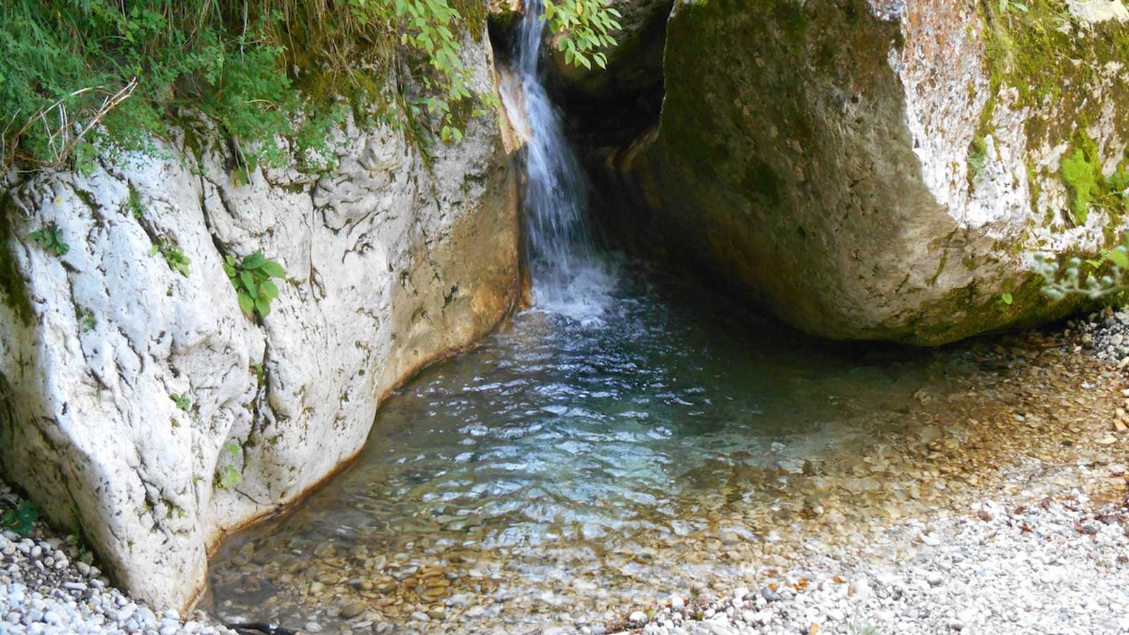
Pietracamela’s toponymic repertoire also includes an extensive network of waterfalls, whose names are directly derived from the corresponding hydronyms: la Caschìata du Rijë d’Ornë (the Rio Arno Waterfall), la Caschìata du Rijë dë la Puorta (the Rio della Porta Waterfall), and others. At the foot of these roaring, foaming waterfalls, erosion creates a basin, often circular and deep, known locally as a callera (‘cauldron’). The Pietracamela area is particularly rich in these formations: u Callaraunë (the Calderone, in Val Maone), la Callera du Rijë dë la Puorta (the Rio della Porta callera), la Callera dë Caplëvanë (or Capëlacuoṣ̌ ta) [the Capolevene (or Capolacosta) callera], la Callera du pauntë du mëijenë (the mill bridge callera), la Callera dë Zazeglë (the Zazeglë callera, in the lower part of the village, where sewage was discharged). On St John’s Day, young people traditionally marked the beginning of the bathing season at the Callera Ronna (the large callera), having first dug out its bed to make the pool deeper.
Finally, other man-made structures indirectly associated with hydronyms should also be mentioned, including bridges: u Puntë dë lë Cannavunë (the Cannavine Bridge, ‘a very long and high bridge. In the past, it had no railings and people were afraid to cross it. It stood not far from the Paolini family residence’), u Puntë du Fussë Zeglë (the Fosso Piccolo Bridge), u Puntë du Fussë Ronnë (the Fosso Grande Bridge), u Pëntëciglë dë Marënerë (the Marinaro Footbridge), and others; as well as dams and reservoirs: la Diga dë Vadëijamë (the Vadiamo Dam), u Vascaunë (the large reservoir at Prati di Tivo), and so on.
Several sources (primary sources: the extensive family memories shared by Ailana Paoletti, our principal informant, those of Lidia Montauti, the handwritten notebooks of the poet Ginevra Bartolomei, and the observations of Graziano Mirichigni; secondary sources: Davide Boccia’s study of Pietracamela’s toponymy) allow us to document this intangible heritage, beginning with the identification and location of the watercourses (or specific stretches of them, from an odological perspective) that run alongside the village: u Rijë d’Ornë (Rio Arno), u Rijë Resë (Rio Ruso – a stretch of the Rio Arno), u Rijë dë la Puorta (Rio della Porta, which flows through Piazza degli Eroi), u Fussë Zeglë (Fosso Piccolo), u Fussë Ronnë (Fosso Grande), u Fussë dë Vina Cacaccìara (Fosso di Vena Cacacciara), u Fussë dë lë Ruotëlë (Fosso del Rotolo), l’Acqua dë Suprataurë (Acqua di Sopratore), and so on. The alternation between the adjectives ronnë and zeglë reveals how the network of hydronyms forms a genuinely interconnected system of names: there can be no small stream without a large one.
Other hydronyms refer to more precisely defined locations, such as the names of natural springs, which can be distinguished – again from a perspective of topological complementarity – between the Upper Lands (Terre alte): la Funta dë Tevë (Fonte di Tivo), l’Acqua dë Vulvërë (Acqua di Vulvërë), Funta dë Quroija (Fonte Corea), Funta Crëṣ̌ tëijana (Fonte Cristiana), Funtimuonnëchë (Fontemonache), Funta Barelë (Fonte Barile), Funta Carvaunë (Fonte Carbone); and the Lower Lands (Terre basse), closer to the village: l’Acqua dë Vadëjiamë (Acqua di Vadìano), Funta Sëṣ̌teglia (Fonte Sestiglia), lë Funtë (le Fonti), l’Acqua dë suglë Quanelë (Acqua di sul Canale, near Santa Barbara), l’Acqua du Fërrerë (Acqua del Ferraio, near Sarachino), l’Acqua Peca (Acqua poca), lë Fëntëciallë (le Fonticelle), l’Acqua dë la Canela (on the path leading to the Forchetta Pass). In several cases, hydronyms, toponyms and anthroponyms (the names of individuals, families or lineages) coincide, confirming the strong internal cohesion of these linguistic elements.
The cultural significance of toponyms and their role in shaping local identity become subtly apparent when they are translated into Italian, a process that can sometimes prove problematic. One example is [Funta dë] Qrojia, where qrojia means ‘flatulence’ (probably referring to the characteristic popping sound produced by the spring), a meaning that has been softened and Italianised as ‘corea’ on topographical maps.
The interaction between water and human activities is reflected in several toponyms, including those referring to livestock watering troughs (triucchë in Pretarolo, built immediately beside a spring), often identified through deictic expressions: i Jabbëvëratèrë (in the hay-barn area), a Partëlafaunta (at Portafontana), a Suprataurë (at Sopratore), illë Paglìarë (at Pagliare), i Partapuotë (at Portapiedi), and so on. This interaction is particularly evident in the name of the district u Tëraterë (the wool-stretching grounds). The tiratori were artisans specialising in the final stage of wool processing, known as tiratura, which followed weaving and fulling. The woollen cloth was soaked and then spread out in the sun across the surrounding fields. The tiratori were responsible for stretching and tensioning the fabric to achieve the required dimensions, maintaining an even weave and correcting any imperfections. Wool production served both domestic needs and local and external markets.
Pietracamela’s toponymic repertoire also includes an extensive network of waterfalls, whose names are directly derived from the corresponding hydronyms: la Caschìata du Rijë d’Ornë (the Rio Arno Waterfall), la Caschìata du Rijë dë la Puorta (the Rio della Porta Waterfall), and others. At the foot of these roaring, foaming waterfalls, erosion creates a basin, often circular and deep, known locally as a callera (‘cauldron’). The Pietracamela area is particularly rich in these formations: u Callaraunë (the Calderone, in Val Maone), la Callera du Rijë dë la Puorta (the Rio della Porta callera), la Callera dë Caplëvanë (or Capëlacuoṣ̌ ta) [the Capolevene (or Capolacosta) callera], la Callera du pauntë du mëijenë (the mill bridge callera), la Callera dë Zazeglë (the Zazeglë callera, in the lower part of the village, where sewage was discharged). On St John’s Day, young people traditionally marked the beginning of the bathing season at the Callera Ronna (the large callera), having first dug out its bed to make the pool deeper.
Finally, other man-made structures indirectly associated with hydronyms should also be mentioned, including bridges: u Puntë dë lë Cannavunë (the Cannavine Bridge, ‘a very long and high bridge. In the past, it had no railings and people were afraid to cross it. It stood not far from the Paolini family residence’), u Puntë du Fussë Zeglë (the Fosso Piccolo Bridge), u Puntë du Fussë Ronnë (the Fosso Grande Bridge), u Pëntëciglë dë Marënerë (the Marinaro Footbridge), and others; as well as dams and reservoirs: la Diga dë Vadëijamë (the Vadiamo Dam), u Vascaunë (the large reservoir at Prati di Tivo), and so on.
Testimony of Ailana Paoletti
Memories of a callera in Pietracamela.
Pietracamela (TE), January 2026.
Recording by Ailana Paoletti.
Aligi Bonaduce Archive.
Pietracamela (TE), January 2026.
Recording by Ailana Paoletti.
Aligi Bonaduce Archive.
Listen to the track

The Resilience of Water
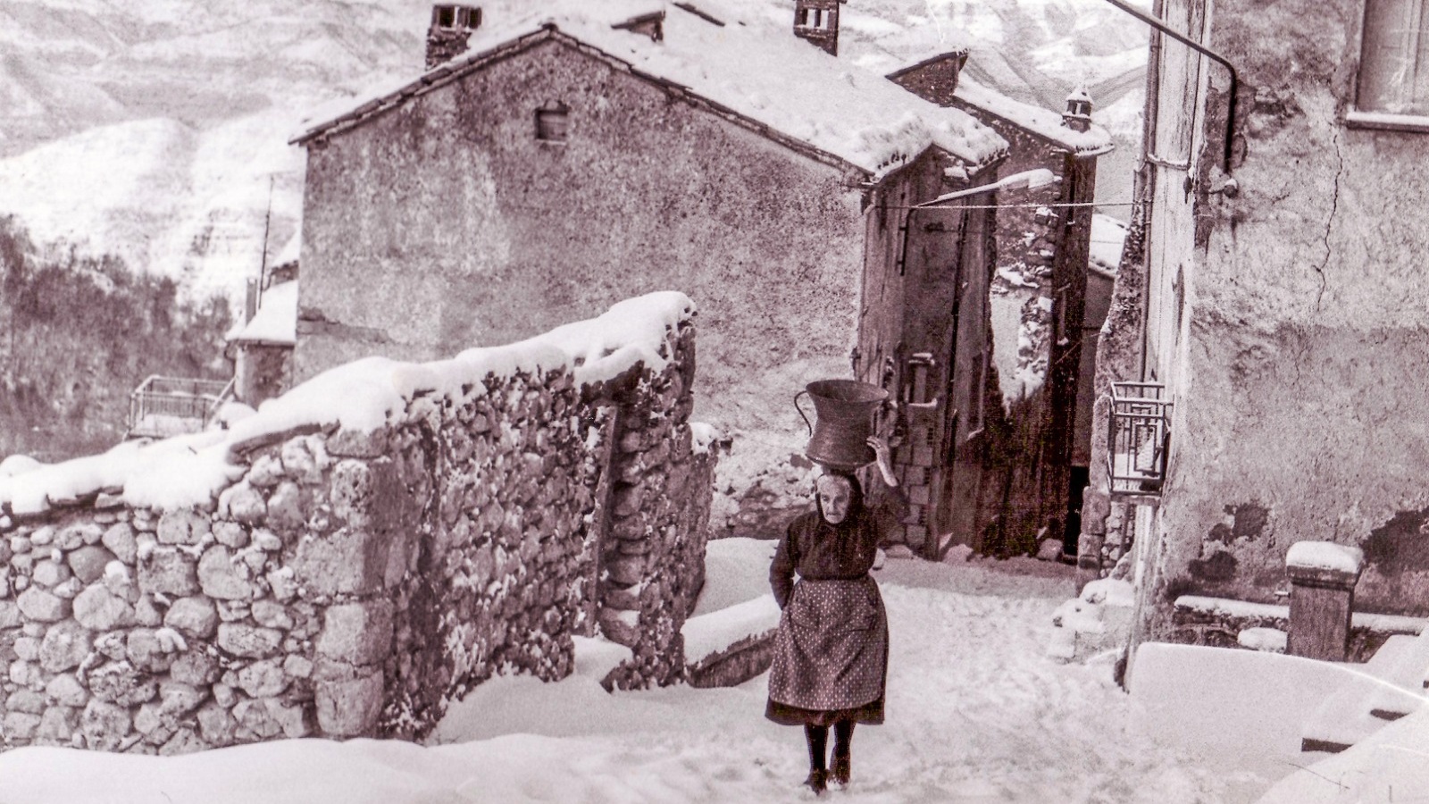
Annina Paglialonga, Aligi Bonaduce’s grandmother, carrying a conca in winter.
A woman walks along a snow-covered alley in Pietracamela, balancing a conca filled with water on her head.
Photo by Aligi Bonaduce.
Pietracamela (TE), c. 1965.
Aligi Bonaduce Archive.
Photo by Aligi Bonaduce.
Pietracamela (TE), c. 1965.
Aligi Bonaduce Archive.
The Resilience of Water
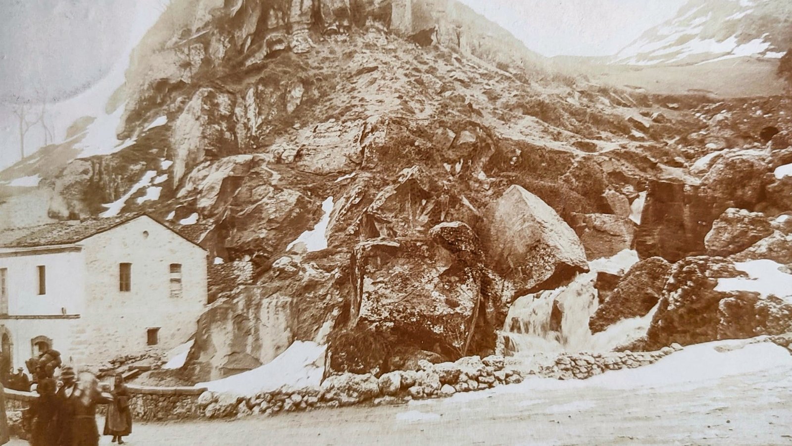
In the square of Pietracamela
A watercourse flows between outcrops of rock, carving and shaping the landscape and revealing the deep connection between the environment and the local community.
Photo by Aligi Bonaduce.
Pietracamela (TE), 1920-1930.
Aligi Bonaduce Archive.
Photo by Aligi Bonaduce.
Pietracamela (TE), 1920-1930.
Aligi Bonaduce Archive.
The Resilience of Water
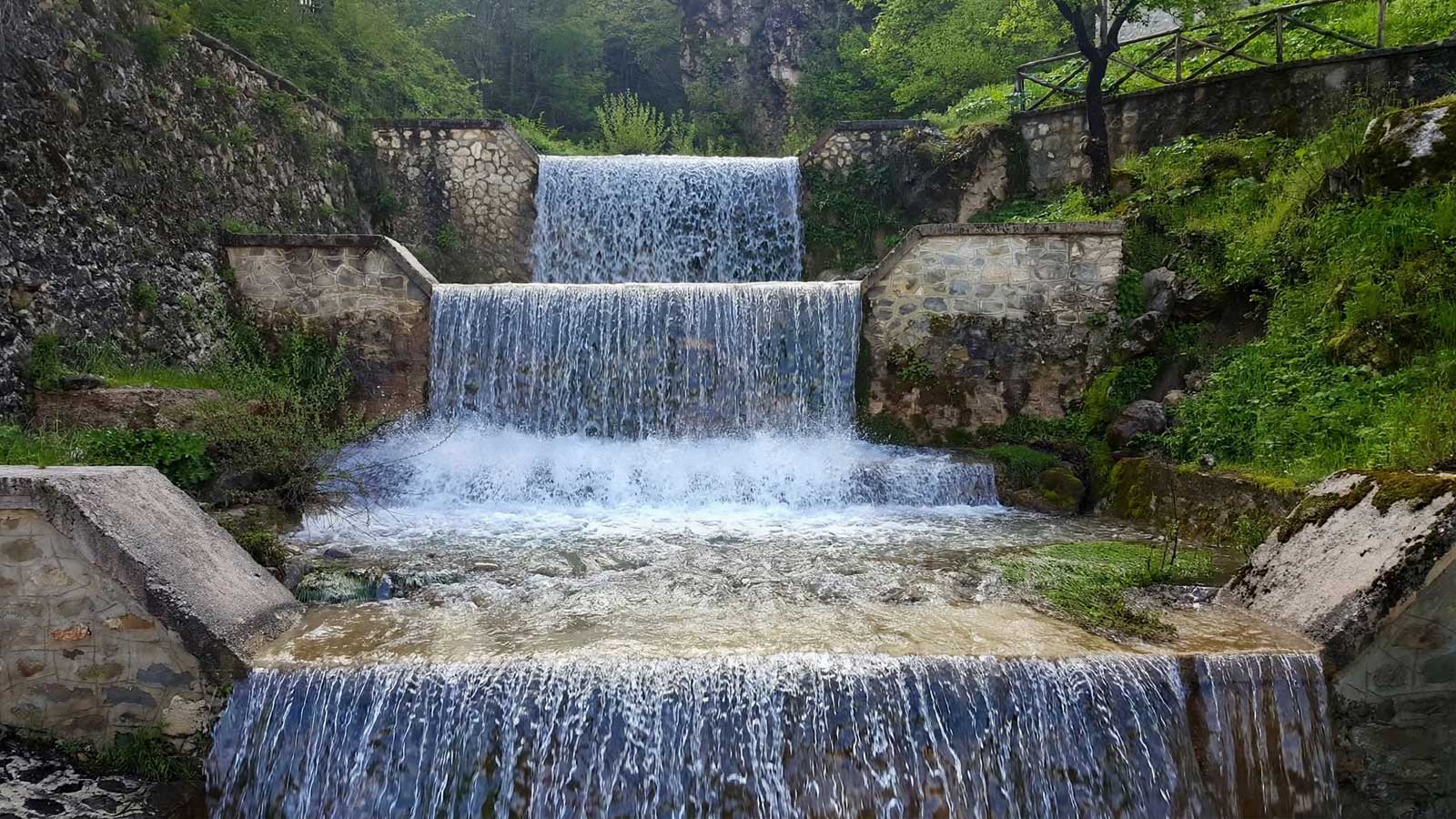
Rio della Porta
U Rijë dë la Puorta, Rio della Porta, runs through Piazza degli Eroi.
Photo by Graziano Mirichigni.
Pietracamela (TE), 2018.
Graziano Mirichigni Archive.
Photo by Graziano Mirichigni.
Pietracamela (TE), 2018.
Graziano Mirichigni Archive.
The Resilience of Water
Rio Arno
Water cascades over boulders and rocky ledges, forming a natural plunge pool – known locally as a callera – shaped by erosion.
Photo by Graziano Mirichigni.
Pietracamela (TE), 2014.
Graziano Mirichigni Archive.
Photo by Graziano Mirichigni.
Pietracamela (TE), 2014.
Graziano Mirichigni Archive.
The Resilience of Water
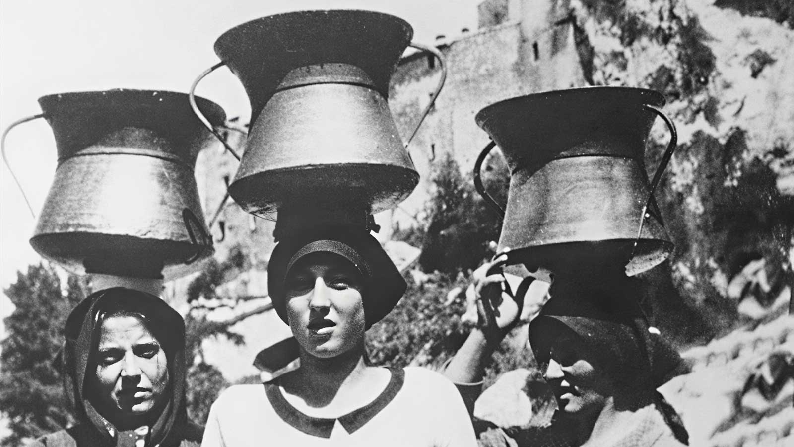
Copper water vessels
Women from Pietracamela with the traditional copper vessel used to fetch water from the river or spring for various domestic purposes
Photo by Aligi Bonaduce.
Pietracamela (TE), 1930s.
Aligi Bonaduce Archive.
Photo by Aligi Bonaduce.
Pietracamela (TE), 1930s.
Aligi Bonaduce Archive.
Watch the video
Fonte delle monache
Ailana Paoletti recounts the folk origins of the hydronym Fonte delle Monache.
Pineto (TE), July 2026.
Filmed by Silvia Pallini.
Associazione LEM-Italia Archive.
Pineto (TE), July 2026.
Filmed by Silvia Pallini.
Associazione LEM-Italia Archive.
Cultural transmission and protection
Pietracamela’s hydronymic heritage, together with the broader body of place names associated with it, is threatened by at least four major factors, which often occur simultaneously and are closely interrelated. First and foremost, the gradual decline of the local language, traditionally transmitted orally, whose intergenerational transmission is increasingly at risk, partly due to the depopulation of mountainous areas. These combined circumstances inevitably lead to the erosion of oral memory and, consequently, to the loss of knowledge about the local landscape, including, of course, its toponymy. Finally, the disappearance of traditional occupations, changes in social practices and transformations in land use make the landscape increasingly ‘opaque’: less frequent, less familiar and therefore less readily understood.
The testimonies collected within a vibrant online Pretarolo community provide valuable insights into this process and highlight the importance of reviving the memory of places: «Lidia, this is the first time I’ve heard of Funta Sëṣ̌teglia […] The damp earth from Funta Sëṣ̌teglia was used to make Nativity scene figurines. [The spring] is located ‘a couple of gunshots away from the village’. You take the path towards Contrad’Arno and continue until you reach the stream, whose waters tumble over countless small waterfalls among white limestone boulders, smoothed by the waters of the Rio d’Arno and covered in moss […] This is where skilled elders used to gather willow branches for basket weaving. Children, meanwhile, would collect the damp clay to model little sheep, houses and human figures…».
This and other examples illustrate the emergence of narrative toponymy (Agresti et al. 2020; Agresti and Pallini 2015), whereby place names themselves give rise to a wealth of stories, whether factual or mythological, becoming genuine anchors of the landscape’s collective memory. From this perspective, the linguistic heritage associated with hydronyms does more than simply name places: it activates and structures an interconnected system of narratives, knowledge and practices. In the context of efforts to revitalise the Pretarolo language and culture, these narratives could provide a starting point for connecting the linguistic and toponymic dimensions of local heritage with cultural tourism, thereby offering an original approach to one of Pietracamela’s key areas of development.
More broadly, recent years have witnessed the consolidation of an online Pretarolo community, made possible by technological developments, which has succeeded in bringing together Pretaroli and Pretarofili, including members of the diaspora, around a shared programme of language corpus planning and the promotion of the language’s social and heritage value. The recently adopted regional law promoting the languages and dialects of Abruzzo may provide an institutional framework for pursuing these efforts. Within this interplay of language, memory and place, hydronyms continue to represent a living form of shared knowledge.
The testimonies collected within a vibrant online Pretarolo community provide valuable insights into this process and highlight the importance of reviving the memory of places: «Lidia, this is the first time I’ve heard of Funta Sëṣ̌teglia […] The damp earth from Funta Sëṣ̌teglia was used to make Nativity scene figurines. [The spring] is located ‘a couple of gunshots away from the village’. You take the path towards Contrad’Arno and continue until you reach the stream, whose waters tumble over countless small waterfalls among white limestone boulders, smoothed by the waters of the Rio d’Arno and covered in moss […] This is where skilled elders used to gather willow branches for basket weaving. Children, meanwhile, would collect the damp clay to model little sheep, houses and human figures…».
This and other examples illustrate the emergence of narrative toponymy (Agresti et al. 2020; Agresti and Pallini 2015), whereby place names themselves give rise to a wealth of stories, whether factual or mythological, becoming genuine anchors of the landscape’s collective memory. From this perspective, the linguistic heritage associated with hydronyms does more than simply name places: it activates and structures an interconnected system of narratives, knowledge and practices. In the context of efforts to revitalise the Pretarolo language and culture, these narratives could provide a starting point for connecting the linguistic and toponymic dimensions of local heritage with cultural tourism, thereby offering an original approach to one of Pietracamela’s key areas of development.
More broadly, recent years have witnessed the consolidation of an online Pretarolo community, made possible by technological developments, which has succeeded in bringing together Pretaroli and Pretarofili, including members of the diaspora, around a shared programme of language corpus planning and the promotion of the language’s social and heritage value. The recently adopted regional law promoting the languages and dialects of Abruzzo may provide an institutional framework for pursuing these efforts. Within this interplay of language, memory and place, hydronyms continue to represent a living form of shared knowledge.
OTHER ASSETS IN THE SAME MUNICIPALITOTHER ASSETS IN THE SAME MUNICIPALITY

The secret word
The jargon of Pietracamela carders

Stornelli for Baby Jesus
Polyphonic singing in Pietracamela

A worthy language
The dialect of Pietracamela